
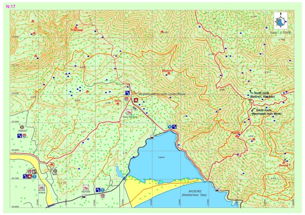
Kınık – Yukarı Beymelek – Bonda T.
As an alternative to the northern route that can be seen in Section 16, the southern route which goes right from the bridge on the main road that provides crossing over Demre creek can be taken after the ancient settlement of Myra. The route continues along the asphalt road and ascends through the Kınık settlement that is 1,5 kilometers further; then it enters scrubland. The path, which progresses among scrubs that are the typical vegetation in the Mediterranean, reaches the main road within the village by passing in front of the Ision ruins.
The southern of the Lycian road which continues to go south (towards the sea) skirts around the lagoon by heading east after reaching the main road at the coast. The route continues on the ancient road which ascends to the east from the opposite of the strait side of the lagoon where the lagoon meets the sea and climbs up the Bonda Hill where many archaeological settlements exist.
The path which runs from the east of Kaklık Hill, on which the entire Beymelek, the lagoon and even the Demre district can be viewed, and heads east in the direction of Finike after merging with the northern route.
Along the southern route, all essential needs can be met via the stores and hotels in the settlements of Demre and Upper Beymelek. The historic houses in the settlement of Yukarı Beymelek have been renovated and put into services as facilities which provide local foods and economical accommodation for travelers.


YILANBAŞI (PARTAESSOS)
An ancient road which extends to Yılanbaşı location by starting at Karacaören and passing the Günağı Church provides access to the classical period castle at Yılanbaşı. The high hill on which the well-preserved castle of which even the construction plan can be construed stands has a complete view of the axis of Beymelek, Myra and Kekova. The walls have been built out of regional stones and these are generally field stones. The walls of different techniques and stone types within the defense system that was formed in consistency with the topography of the area indicate that the settlement has been used via renovations and repairs during the time from the classical period to the Byzantine period. While most of the sarcophaguses on the site are broken, a few of these have survived until the modern day.
YUKARI BEYMELEK
Yukarı Beymelek, which is the main settlement in Beymelek, has architectural examples from both ancient settlements and traditional Turkish settlements. The ancient settlemen is at an altitude of 600 meters from seal level on a crescent-shaped hill. Since the northern side of the hill has steep, rocky terrain, the domicile settlements are on the southern side. There are remains belonging to the keep and the casyle on the hill. The entrance to the keep was provided via rock steps. The water for the castle, which lacks any natural water sources, was supplied via cisterns. There is a Byzantine church at the western end of the castle. When people transferred from nomadic life to permanent settlement during the early republican period, domiciles that faced the lagoon were built ob the skirts of the Beymelek ancient settlement site. The structures, for which plans, construction and materials that are similar to those of the Lycian tradition were adopted, are generally made of stones, mud and wood. These have a single room, a porch, an interior hearth, flat dirt roof and unglazed windows with wooden shutters.
BONDA
The Boldağ village within the district of Finike can be accessed by going towards Asarönü after the fork on the road at Turunçova and following a path which gradually rises for approximately 20 kilometers. In the ancient period, the various settlements within the region that is called Bonda pn the Gülmez Mountain, were built on high hills at altitudes of 650 to 900 meters from sea level which had a bird’s eye view of Göklimanı. One of the reasons this location is called Boldağ (meaning: “many mountains”) is because there are many mountain ranges in the area. Many defensive castle settlements, wells, cisterns, workshops, churches and sarcophaguses have been encountered in most of the settlements that have a view of the Turunçova and Finike plains and which were inhabited during the Roman and early Byzantine periods. Of these settlements, the one called Bonda is also one of the settlements in the mountainous terrain that makes up the border region of Limyra.
The first part of the settlement to be encountered, which extends on the slopes of a steep mountain 1 kilometer south of Kaklık Hill, is the necropolis; the necropolis, which is on the slope where many sarcophaguses are placed together, is parted from the settlement with a rift hillside to the north. There are shield figures (influence of Pisidia) on some of the Lycian type sarcophaguses with pyramidal roofs which belong to the Roman period. The rocky terrain descends sharply to the east and fortifications that belong to a castle, together with towers belonging to defense buildings, are encountered first while ascending the hill. It is understood that the walls, which were built with dry masonry, were partially renovated with mortar in some later period. There are some other structures which have been integrated into the castle settlement, which can be accessed via carved steps and platforms.
Among the remains that are scattered on an expansive area, cisterns built for providing water supply, domiciles and the ruins of an early Byzantine period church with its additional sections can be discerned. The stand-alone workshops of which the vats were built by being carved into the bedrock and the ones with pressure lever holes in the middle part that were built via formation of square shaped rooms are olive and grape processing workshops for agricultural purposes. The architectural piece made out of large stone blocks with blade slots on its doorstones belongs to a more sophisticated structure.
ISION
The Ision Towers, which comprise the safety structure for the nearby area along the Myros Valley from Beymelek to Gürses and which were built both as a part of the defense network and as to protect the the local ruler’s self, lands and products, are dated back to the 2nd century BC. It is said that the the place which is currently called the Beymelek Lagoon used to be a bay and this area was called Ision, which meant “the place of the goddess Isis”, by the builders of the castle as a tribute to the Egyiptian gods. The castle and the architectural remains around it indicate that Ision was a very important, sheltered farm settlement. The settlement, in which there are no elements indicating the Byzantine period, is known to have been used during the Roman period.
In Ision, the architecture of which is a good example of the Hellenistic period towers, the castle is square shaped and supported by two towers, one on the north and one on the west. The towers have 3 floors and have been well preserved until the modern day. The main entrance of the castle is from the south and opens up to the courtyard between the towers. There are wooden floors within the towers and every floor has windows for lighting. The existence of many wineries that are concentrated on the west of the castle indicate that the farm had a high capacity for wine production. The cistern which has been carved into the bedrock within the northern tower was supplied with water from the surface waters via a channel extending from the north. Two small chapels belonging to the 6th century, which extend from east to west beside Dalyan Lake, are Byzantine period remains of Beymelek that have survived until the modern day.