
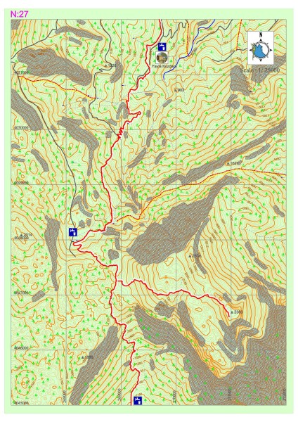
Tahtalı Dağı – Yayla Kuzdere
The western route of the Lycian road continues to the north from the Beycik settlement and passes across the strait on the west of the Tahtalı Mountain. It runs through centuries-old cedar and juniper trees and snowy hollows. Eventually, the road descends onto a small plain in the middle of which a single house rests. Before arriving at this point, a path that detaches from the road can be taken to access the peak of Tahtalı Mountain.
The small plateau on which the house stands is inhabited during summer, while it is under heavy layers of snow in the winter. It provides potable water by means of the fountain between tree hollows, at the south of the house.
When starting from the plain, Lycian road signs should be paid attention to in order to be able to progress in the direction of Kuzdere Plateau; this is because there are other tracks, signs and markings around the area.
Lycian road reaches the settlement on Kuzdere Plateau after descending in parallel fashion to a large landslide area which is formed by creeks. The fountain in front of the village mosque provides potable water. The road follows the upper main road in the junction within the village and continues on the main road for a while.
After a few hundred meters, travelers should be careful since the signs that indicate the Lycian road, which ascends from beside the house gardens, are blotted out. Otherwise, they may have to follow the main road to Gedelma settlement, which is 7 to 8 kilometers below. The route within the section is especially enjoyable for those who like Alpine style mountaineering.


